-

- Color Infrared
-

- Gameland boundaries, roads, trails, GPS Points

-

- In Field GPS Points of Game Sign
-

- Hillshade
-

- Areal Imagery
-

- Slope of Terrain
-

- Topographic Maps
-

- Ideal Turkey Habitat
-

- Mapping application and maps on CD
-

- Easy to run maps
-

- 3D Images
-
- Slope and Depth waterproof charts
Overview
Up-Close Outfitters provides very detailed deer and turkey hunting maps in the national and state forest surrounding Asheville NC. Tired of scouting endless hours? Let us do it for you… We can provide very accurate maps of the national forest in the region. These areas include the Pisgah National Forest and the Green River State forest. We use satellite imagery, infrared areal photography, in the field sub-meter gps, and many other resources to held decide where to scout. This could include timber stand classification, creek bottoms, slope, elevation, aspect (direction of sunlight), trails, and much more. We then go in the field and GPS all deer and turkey sign. We can provide on a yearly basis all of this years deer rubs, scraps, and trailsthat we have found with corresponding GPS location points. This is a full time job for us and we aim to produce very accurate data. We also provide local lake maps for small reservoirs in the region. We are fully equipped and capable of underwater hydro-graphic mapping. Up-Close Outfitters uses Hypack (surveying software) to digitize the underwater bottom. We then GPS all key locations to export to GIS. With GIS we produce a “smart map” that can help determine seasonal migration patterns of bass, walleye, and trout.
National Forest Hunting Maps
Up-Close mapping provides national Forest maps for the Pisgah and Nantahala National Forest and is offered in a digital version.
These maps represent the geographic amenities of these forests. Elevation and vegetation play a major role in game travel in the rugged environment of western NC. Look at true color areal images, false colored areal images, elevation models, slope layers, different vegetation stands, gps points of past sign taken by the scouting of Up-Close Outfitters, trails, contours, and much more.
The digital version comes on CD with an application that needs to be installed on a desktop/laptop. Arc Explorer is a simple application and experimentation will familiarize you with its workings. As the map is geo-referenced the cursor position is shown with lat/long readout. Zooming in and out, measuring distances and adding your own data are primary functions of this application. You can add data captured with a GPS device by converting the data to a file in GPS Exchange Format. Numerous third-party and GPS manufacturer utilities exist to perform this conversion. If you have a data cable you can plug your GPS into your desktop/laptop and experience live tracking.
Track deer movement and plan your hunt most efficiently without spooking the game with Up-Close Maps.
This product is the result of thousands of man-hours and is a very useful tool for planning, navigating, recording and analyzing local game migration and geographic features.
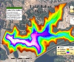
Custom Local Lake Maps
Up-Close maps show under-water topography which is offered in both hard copy and digital version.
These maps cover lakes in western NC and up-state SC.
The scale of the map depends on the size of the lake. Some hard bound copies are split into two to help represent their size. They are printed on a 150 gram gloss art paper through a color laser printer that produces an excellent image which is color-fast and waterproof. These are completely custom made by Up-Close Outfitters.
The digital version comes on CD with an application that needs to be installed on a desktop/laptop. Arc Explorer is a simple application and experimentation will familiarize you with its workings. As the map is geo-referenced the cursor position is shown with a lat/long readout. Zooming in and out, measuring distances and adding your own data are primary functions of this application. You can add data captured with a GPS device by converting the data to a file in GPS Exchange Format. Numerous third-party and GPS manufacturer utilities exist to perform this conversion. If you have a data cable you can plug your GPS into your desktop/laptop and experience live tracking.
This product is the result of thousands of man-hours and is a very useful tool for planning, navigating, recording and analyzing local lakes.
Price – varies due to lake size

Leave a comment